نمایش نتیجه 1 تا 4 از 4 نتیجه یافت شده برای Isopach:
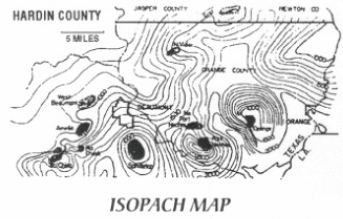
a map that shows contours between points of equal formation thickness. It may also show depth of the zone.
n: a geological map of subsurface strata showing the various thicknesses of a given formation as a series of contours. It is widely used in calculating reserves and in planning improved recovery projects.
نقشه ی هم ضخامت
n: a contour line drawn on a map joining points of equal thickness in a stratigraphic unit.
n: a sedimentary rock composed of individual mineral grains of rock fragments between Yl6 and 2 millimeters (0.062 and 0.078 inches) in diameter and cemented together by silica, calcite, iron oxide, and so forth. Sandstone is commonly porous and permeable and therefore a likely type of rock in which to find a petroleum reservoir. sandthickness map n: a map that shows the thickness of subsurface sands. See isopach map.
granular sedimentary rocks with grain sizes between 0.0625 and 2mm. The pore space where hydrocarbons may be held is between the grains.
ماسه سنگ
© ۱۳۹۲-۱۳۹۷ این اثر شامل قانون حمایت از مولفین بوده و هرگونه کپی برداری از آن ممنوع است.